PEI Report Chapter 2 : Click Here
PEI Report Figures : Click Here

Description of the project
The project comprises the improvement of the A66 between the M6 at Penrith and the A1(M) at Scotch Corner.
The project has been split into eight schemes. It includes upgrading the existing six single lane sections to dual two-lane all-purpose roads with a speed limit of 70mph, with the exception of a section of the A66 from the M6 junction 40 through Kemplay Bank, which will have a speed limit of 50mph. The project also includes amendments to existing junctions and accesses within these sections.
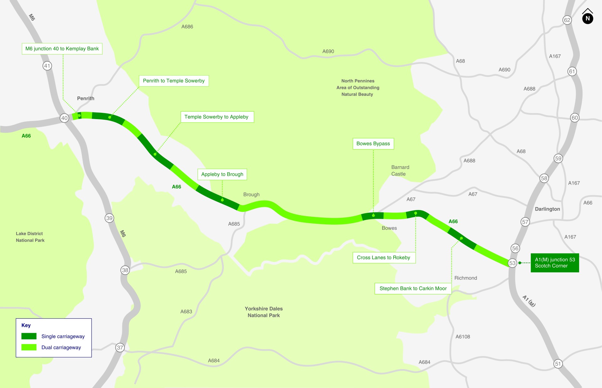
Some of the eight schemes involve online widening of the carriageway and some are offline (i.e. new sections of road that follow a different route but reconnect into the main A66 alignment). Along with dualling six sections of existing single carriageway, other improvements will be made along the route, such as junction improvements at the M6 Junction 40 at Penrith and minor improvements to the existing dual carriageway sections of the A66 within the existing highway boundary (for example new signs or road markings).
The eight individual schemes are as follows:
- M6 junction 40 to Kemplay Bank
- Penrith to Temple Sowerby
- Temple Sowerby to Appleby
- Appleby to Brough
- Bowes Bypass
- Cross Lanes to Rokeby
- Stephen Bank to Carkin Moor
- A1(M) junction 53 Scotch Corner
Scheme details
The design of the proposed project is ongoing. As detailed in Chapter 2: The Project of the PEI Report, the PEI Report reports on the assessment of the alternative alignments for certain schemes that have been considered since the Preferred Route Announcement (PRA) for the project. A summary description of each of the schemes is provided below including alternative alignment routes that have been assessed.
M6 junction 40 to Kemplay Bank

The key features of this scheme are:
- Three-lane circulatory carriageway and new road markings on the existing M6 junction 40 roundabout.
- Widening of the A66 eastern arm from two to three lanes in each direction between the junction 40 and Kemplay Bank roundabout.
- Widening of the M6 North, M6 South, A66 East, A66 West, and A592 Ullswater Road approach arms to provide additional lanes and a dedicated left turn facility.
- New on-slip and off-slip roads at the A6 and A686.
- New underpass beneath Kemplay Bank roundabout.
- The underpass off Carleton Avenue will be retained and extended to accommodate the widening of the A66.
- New controlled crossings for existing shared cycle/footway connections that cross the scheme.
- All existing accesses and cycleways and footways will be accommodated either through being retained or will be rerouted close by.
- Reduced speed limit to 50mph between junction 40 and Kemplay Bank roundabout.
Penrith to Temple Sowerby

The key features of this scheme are:
- Full dualling of the existing A66 single carriageway between Penrith and Temple Sowerby.
- Widening of the existing carriageway to form one side of the new dual carriageway and constructing the second side of the carriageway north of the existing A66.
- Removal of existing crossing points over the existing A66 but maintaining access for agricultural vehicles via two new private access structures, and for landowners through new access tracks north and south of the route.
- New junction to replace the Centre Parks junction.
- New left-in/left-out junctions with associated acceleration and deceleration lanes at the B6262, the access to the Whinfell Holme Wastewater Treatment Works, and the access to St Ninian’s Church.
- Amenity parking area with footway access to the Countess Pillar historic monument.
Temple Sowerby to Appleby
This scheme has three alternative alignments that have been considered and are described below.
Blue Alternative (Evolved version of the Preferred Route announced in Spring 2020)

The key features of this scheme are:
- A new offline bypass around the north of Kirkby Thore.
- A new bypass to the north of Crackenthorpe.
- Follows the PRA alignment from the western end of Kirkby Thore to the junction at the British Gypsum site to the north of Kirkby Thore.
- A multi-span viaduct over the Trout Beck and its floodplain.
- A number of new junctions, bridge structures and improvements throughout the route.
Orange Alternative

The key features of this scheme are:
- Bypass falls slightly to the south of the existing A66 and then follows a similar alignment to the existing A66 through Kirkby Thore.
- Trout Beck crossing at Bridge End.
- A new bridge associated with the new A66.
- Follows the PRA alignment from Long Marton junction to north of Crackenthorpe.
- Upgrade Priest Lane to a 6m wide carriageway.
Red Alternative

The key features of this scheme are:
- Follows the PRA alignment design from the western end of Kirkby Thorpe and up to Sleastonhowe Lane.
- 250m watercourse crossing of the Trout Beck.
- Watercourse crossing over Keld Syke.
- New junction at Long Marton.
- Follows the PRA alignment design to the north of Crackenthorpe.
Appleby to Brough
This scheme has been split into three sections (western, central and eastern) and alternative alignments have been considered for the central and eastern sections, as described below. It should be noted that the alternatives for each section could be brought together in any combination, forming four route alternatives.
Black-Black-Black (Evolved version of the Preferred Route announced in Spring 2020)

- Online widening with a new westbound carriageway to the south of the existing carriageway between Coupland Beck and Brough.
- De-trunking of sections of the existing A66.
- A new left-in/left-out junction at Café 66 on the A66 westbound carriageway.
- A new junction to link the B6259 to Sandford/Warcop.
- New left-in/left-left out priority junctions at Warcop on the westbound and eastbound carriageways.
- A left-only T-junction at Langrigg with appropriate diverge and merge tapers on the westbound carriageway.
- New local roads to the south of the new A66 alignment to link with Flitholme and to the south of the new A66 from Langrigg Lane to the west to link with a new overbridge.
- New underpasses at New Hall Farm, Far Bank End, Wheatsheaf Farm and east of Moor Beck.
- New overbridge for walkers, cyclists and horse-riders near West View Farm within the AONB.
Blue Alternative - Central Section

The key features of this scheme are:
- An alternative central section of the Black Route, shifting 50m south from Wheatsheaf Farm.
- New A66 eastbound carriageway along the existing A66.
- A new westbound carriageway directly south of the existing alignment.
- New crossing structure across the Moor Beck.
- A new underpass to the east of Walk Mill Barn.
Orange Alternative - Eastern Section

The key features of this scheme are:
- An alternative eastern section of the Black Route.
- New dual carriageway south of West View Farm adjacent to the existing A66.
- New crossing structure across the Lowgill Beck.
- Ties back into the existing A66 at Musgrave Lane Overbridge.
- A new farm access underpass on the south side of the new A66.
- De-trunking of the existing A66 with a two-way connection into Main Street at Brough.
Bowes Bypass

The key features of this scheme are:
- Widening of the existing A66 to the north of Bowes.
- A new adjacent eastbound carriageway to the north between the Clint Lane Overbridge and the eastern scheme extents.
- Widening of the A67 to create a staggered junction and a right turn lane for the eastbound slip road.
- Realign the existing eastbound slip road to the north.
- Minor improvements to the existing westbound slip road.
- Upgrade of the Bowes junction to a grade separated junction.
- Extension of Lyndale Farm Underpass and Blacklodge Farm Underpass.
- New access overpass at East Bowes.
Cross Lanes to Rokeby
This scheme has two main junctions (Cross Lanes and Rokeby) and alternative junction arrangements have been considered for each of them, as described below. It should be noted that each of the junction alternatives could be brought together in any combination, forming four route alternatives.
Black (Evolved version of the Preferred Route announced in May 2020)

The key features of this scheme are:
- Dualling of the A66 with a new adjacent westbound carriageway to the south between the B6277 junction at Cross Lanes and the existing Tutta Beck Cottage access.
- New carriageways will be routed to the south of The Old Rectory and St Mary’s Church, re-joining the existing A66 at Rokeby.
- Upgrade of the existing Cross Lanes junction to a new compact grade separated junction.
- Realigning of the B6277 Moorhouse Lane to connect to the new Cross Lanes junction.
- De-trunking of the existing A66 west of St Mary’s Church to Barnard Castle Road.
- A new compact grade separated junction at Barnard Castle Road.
- A new junction at to the west of The Old Rectory and St Mary’s Church.
- A new culvert to accommodate Tutta Beck.
Blue (Cross Lanes) - Alternative junction

The key features of this scheme are:
- A new link road west of the existing Cross Lanes priority junction to link Rutherford Lane to the south and the B6277 Moorhouse Lane to the north.
- Realigning of a section of Rutherford Lane.
- Another new link road to connect Moorhouse Lane to the proposed link road west of Cross Lanes.
- A new culvert to accommodate Tutta Beck.
Red (Rokeby) – Alternative junction

The key features of this scheme are:
- A66 alignment leaves the existing A66 carriageway diverting south around The Old Rectory.
- A new junction to pass underneath the A66 to the Barnard Castle Road.
- A new eastbound slip road (merge) on the north side to connect the de-trunked A66 to the A66 mainline.
- Modification of the existing priority junction (to the north) to accommodate new slip road.
Stephen Bank to Carkin Moor

The key features of this scheme are:
- A new dual carriageway section between Stephen Bank and Carkin Moor Farm to the north of the existing A66.
- A new access underpass to the north of Dick Scott Lane.
- A new bridleway underpass to the north of Warrener Lane.
- De-trunking of the existing A66 to be used as a collector road with a new overbridge to facilitate the revised vertical realignment of Collier Lane.
- A new grade separated junction to the western boundary of the existing alignment of Moor Lane.
- Realigning of the southern section of Moor Lane and placed into a cutting beneath the proposed mainline to connect to the de-trunked existing A66.
- Rerouting of the existing bridleway rerouted along the proposed realigned section of Moor Lane and along the Western Boundary of Mainsgill Farm.
- A new link road to Moor Lane grade separated junction.
A1(M) junction 53 Scotch Corner
 junction 53 Scotch Corner")
The key features of this scheme are:
- Widening of the Middleton Tyas Lane approach to the A1(M) junction 53 at Scotch Corner roundabout, from one lane to two lanes.